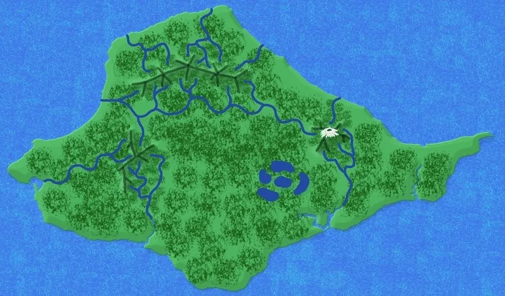
This is the final part of making my Velantia map - needed for some ancient Terrenden history - to be presented in the set A'mara Dawn.
Last time, I created the mountains and shaded them to look almost 3D.
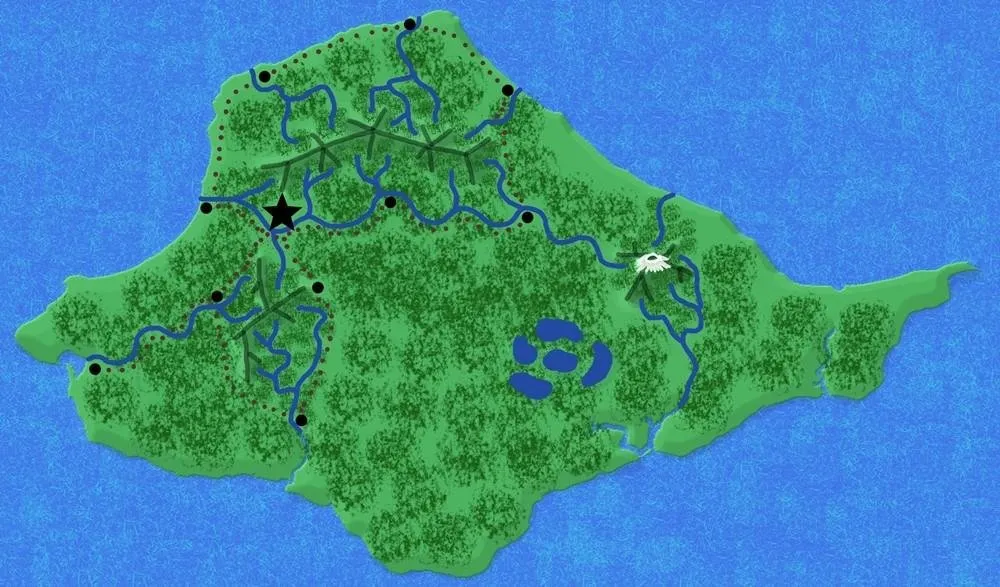
Today, I add vegetation, towns and roads as well as label my map - well, as far as it has been labeled anyway.
Adding vegetation
- I create a new layer called "vegetation" - I actually decided to drag the layer down to just below the mountains so that I can stamp it well.
- I like using the "chalk" brush for the trees, but I choose the less regular one so that the random effect of trees works a little better. I use a smaller brush for fitting trees in the mountains and around the rivers, but because Velantia is a subtropical island (and in ancient times), I want trees all over, so I also use a larger brush to show just how lush this landscape is.
- On this map, although there are many swamps around the lakes, I have only given the vaguest impression, partly because the swamps are also surrounded by trees (largely the fire chestnut.)
Adding towns
- I create a new layer for towns - to remain my top layer.
- I start with the star brush to put my Castel Velantia's position. Obviously named for the castle there, the "of" lost with time.
- I add a few more towns (round paintbrush) here and there, thinking of ease of transportation - whether by boat or by horse. I'm also thinking in terms of where one might need to spend a night along the way... Not everyone has the finest horses, after all.
- I avoid the rough terrain near the volcano and the fire swamps - both are inhospitable and unlikely to be chosen as good places to live in ancient times. Perhaps these areas will end up hosting unkind types including smugglers, but we won't know until more has been revealed of Terrenden's timeline.
Adding roads or trails
- I create a new layer just below the towns layer and call this one "roads" or "trails." I like this one below the towns layer so that I don't mess up my dots with brown stripes... When I'm using the dots I am today, it's less important.
- There are more like trails and less like roads in ancient Velantia, so I use a smaller brush, in brown, and dot them in - remembering that rivers are more easily crossed or forded upstream and make for good navigation for ancient travelers.
- I also think of general trade routes, especially going to the capital.
- Again, the areas around the volcano and the fire swamps are avoided. Both are considered dangerous areas.
Adding a compass rose
A free clip art from Pixabay
- I right click the image, and choose "copy image"
- I paste it as a new layer onto my map.
- I scale it (holding the shift key to keep the ratio)
- I right click the layer and choose "layer to image size"
- I move the layer to where I want it to be.
- I right click the layer again and add an alpha channel.
- I use the color picker tool and click on the black background, then delete the black - to create a clear background.
Labels and final touches
This step, I do on Photoscape because it's simply easier. Okay, I can't turn my text to a weird angle, but that's just fine with me - I can cope with that.
It's very easy to use the text tool on Photoscape and then drag and resize the labels to what I need.
Finally, I throw in a margin border because I think it looks more polished when I do that.


Lori – photographer at Viking Visual, author at A’mara books, student-of-the-world.
Banner by @shai-hulud